
Planning Your Visit
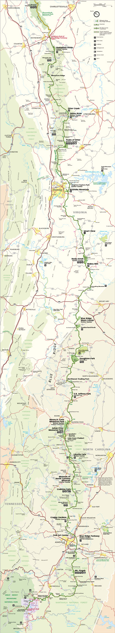
The official website of the Blue Ridge Parkway is that of the National Park Service, www.nps.gov/blri. It is less comprehensive than the Park Service’s website on the Great Smoky Mountains National Park, but it is nonetheless useful in planning your visit. Be sure to download the parkway map at www.nps.gov/blri/planyourvisit/maps.htm or see the version below. Also, many private guidebooks to the parkway have been published – see Books in the Resources section.
Because the parkway is accessible from many major crossroads along its length, you can enter at a large variety of different points and take the scenic roadway in chunks of a few hours or even a few minutes.
Most parkway aficionados say that the most scenic parts of the parkway are from around Boone and Blowing Rock to Asheville, and then from Asheville to the Great Smokies. These are the highest elevation areas of the parkway and offer dramatic mountain views and a diverse selection of types of trees, shrubs and wildflowers.
The parkway is in theory open year-round, but in winter the higher elevations of the parkway, especially north and south of Asheville, often are closed due to ice and snow. Some sections also close periodically for maintenance or to remove rockslides. The Folk Art Center in Asheville, the main Blue Ridge Parkway Visitor Center adjacent to park headquarters near Asheville and the Museum of North Carolina Minerals at Spruce Pine are open year round. Most other facilities, including visitor centers, campgrounds, inns, restaurants and picnic areas, typically begin opening in April and stay open through the fall leaf color in October or early November.
The Blue Ridge Parkway Association is the officially designated marketing partner of the Blue Ridge Parkway. Its members, mostly tourist-related businesses near the park, have worked together more than six decades to promote the park. The website is very helpful, and it has an excellent planning guide to the parkway, available either in paper or as an online download from the association website at www.blueridgeparkway.org. Both versions are free. A free mobile app is also available for smartphones and tablets.
The Blue Ridge Parkway Foundation (www.brpfoundation.org) is a non-profit established in 1997 that helps raise money to support the parkway.
Driving the Parkway
The vast majority of visitors to the Blue Ridge Parkway see it from their autos. Commercial vehicles are banned on the parkway without specific advance permission. You can even be stopped for having a magnetic business sign attached to the door of your car or truck.
The speed limit on the parkway is 45 mph, and in some areas lower. Often you’ll be traveling at 30 mph or slower, so to drive the entire parkway in Virginia and North Carolina will take at least 12 hours, without stopping. To drive the length of the parkway in a leisurely fashion, with stops for sightseeing and meals and overnight stays, plan at least three to five days.
Access Points
Unlike the 105-mile long Skyline Drive in Virginia -- with which the Blue Ridge Parkway connects -- which has only four access points, the Blue Ridge Parkway has dozens of access points along its entire length, typically with an entrance at every major crossroad.
In the Asheville area, there are seven access points – the easiest entrances are from U.S. Highway 70 east of Asheville at Milepost 382, from U.S. Highway 25 at MP 389 and from NC Highway 191 near I-26 at the North Carolina Arboretum at MP 393. You also can access the parkway at Bull Gap (MP 375) via Elk Mountain Scenic Highway or via Reems Creek and Ox Creek roads; Craven Gap (MP 377) via Webb Cove Road; via U.S. Highway 74A in East Asheville/Fairview (MP 385); and via NC Highway 151/Pisgah Highway near Candler that takes you on a very curvy ascent to MP 405 near Elk Pasture Gap.
You can also enter near many other towns and cities along its path, including Cumberland Knob, Sparta, Mount Airy, Blowing Rock, Boone, Linville, Little Switzerland, Spruce Pine, Brevard, Waynesville, Maggie Valley and Cherokee in North Carolina and Waynesboro, Lynchburg, Roanoke and Galax in Virginia.
Weather Reports
Because of dramatic differences in elevation, different sections of the parkway can experience very different weather conditions. A Blue Ridge Parkway weather site launched in 2013 helps visitors follow the rapidly changing nature of parkway weather. The Blue Ridge Parkway Foundation, along with the National Park Service, Appalachian State University and raysweather.com, have partnered to create specialized parkway weather websites — www.BRPweather.com and www.BRPwebcams.org. With weather stations and webcams along the parkway, the weather sites include custom forecasts, live weather conditions, live webcam images and video, radar and satellite imagery and climate information.
Map below courtesy of National Park Service.
All content copyright © Lan Sluder except selected photographs used by permission and brief quotations or other fair use text, which are owned by the copyright holder.
We have made every effort to confirm the accuracy of information on this website, and in the Amazing Asheville book and ebooks, but travel information is subject to frequent change, and no warranty is made, express or implied. Please notify us of any errors or omissions, and we will attempt to correct them as soon as possible. All opinions expressed are those of the author, Lan Sluder, unless otherwise noted.